About 71% of the Earth’s surface is covered in water meaning that protecting the oceans is paramount to the well-being of our planet. Meeting the demands of a growing population has led manufacturing companies to produce increasing numbers of products for consumers which ultimately results in more waste being produced and ending up as ocean pollution.
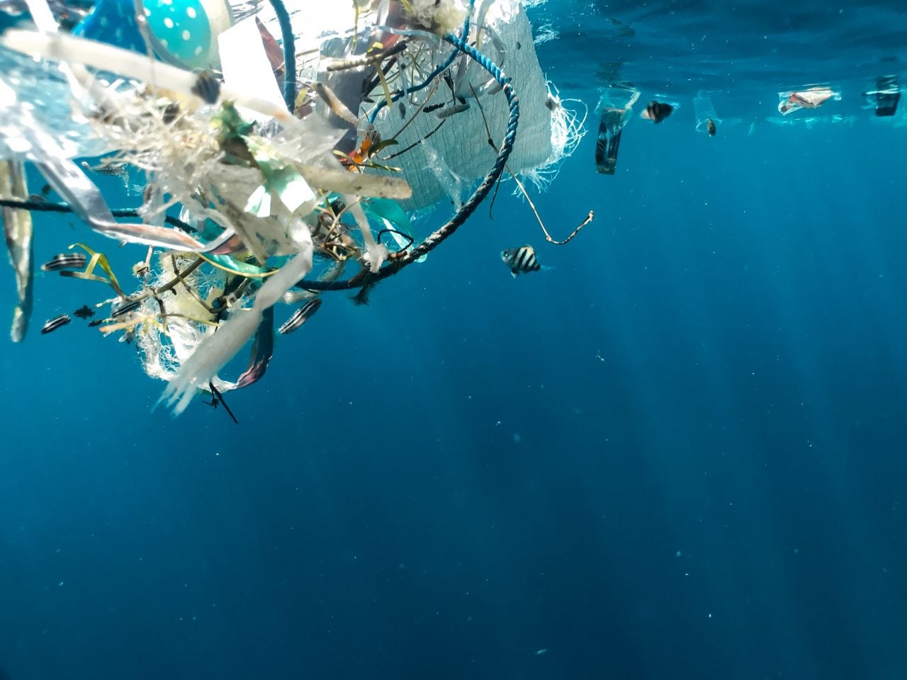
Most of the plastic pollution in the ocean originates on land mainly from household and commercial waste which is transported to the oceans via wastewater, wind, rain and flooding. Lightweight straws, plastic bags, and wrappers are easily carried across land or via river networks to the coast and into the sea.
There are an estimated 5.25 trillion pieces of plastic waste in our oceans with 70% of the debris sinking to the seabed and into the ocean’s ecosystem, 15% floating in the ocean and 15% being washed up on our beaches. (Condor Ferries – Marine & Ocean Pollution Statistics & Facts 2020-2021.)
Alongside plastic World Animal Protection’s report Fishing’s phantom menace estimates ghost nets – abandoned or lost fishing nets – entangle and kill at least 136,000 seals, sea lions and whales every year.
The shipping industry can help the clean-up of this global waste issue by mapping it with geotagged pictures. This allows industry bodies to identify areas that need attention when it comes to clean-ups and pollution monitoring.
How well do you really know your competitors?
Access the most comprehensive Company Profiles on the market, powered by GlobalData. Save hours of research. Gain competitive edge.
Thank you!
Your download email will arrive shortly
Not ready to buy yet? Download a free sample
We are confident about the unique quality of our Company Profiles. However, we want you to make the most beneficial decision for your business, so we offer a free sample that you can download by submitting the below form
By GlobalDataCreation to capture
Launched in December 2020, non-profit organisation Eyesea was created with a mission to map global pollution and maritime hazards. The organisation has developed software in the form of an app that enables the use of geotagged pictures to map maritime pollution across the globe.
Founder Graeme Somerville-Ryan created Eyesea when he was discussing the issue of pollution and the environmental impacts of shipping with shipping companies. Somerville-Ryan was also in discussion with mapping agencies involved with corruption and port mapping. The combination of these two issues inspired the creation of the Eyesea app.
Somerville-Ryan said: “We were walking around with two bits of A4 paper with the idea. In six weeks, we had a fleet of about 800 ships offered to the project. What we found was that there was a huge desire in the industry to actually take a leadership role on pollution.”
The app enables the user to select from a range of pollution categories including net, trash, and oil for the user to select depending on the nature of the pollutant found and upload a photo that is geotagged and timestamped, allowing the team at Eyesea to locate where the pollution was found.

The use of collected data
Eyesea chose to use images to collect pollutant data due to their strong impact on viewers alongside the ease and speed of taking a photo while at sea.
Once Eyesea has collected data it constructs comprehensive maps and presents them to industry bodies, aiming to empower government and NGO environmental efforts.
The maritime pollution maps will be overlayed with charts that show the effects of current, tide and wind on the movement and location of pollution instances. These charts will be accompanied by pollution heat maps enabling Eyesea to identify the components of maritime pollution and where the clean-up initiatives have had the greatest impact.
Somerville-Ryan explains: “The goal is to have the information publicly available but we’re not a police force; we don’t want to embarrass ports; we don’t want to destroy beaches tourism industry. We’re much more interested in using the maritime anti-corruption network model.”
“Let’s say we go to Wellington, New Zealand, and we’ve identified a swathe of pollution. We will then go to the local council and try to work with them around ‘do you need resources, can we help you, if it’s floating can we help you, can we organise something with the shipping community.’”

Collaboration not competition
Seafarers across the globe taking snapshots of pollution presents the issue of naming and shaming. However, the data collected from the Eyesea app is completely anonymous to those using the app meaning that ports and shipping locations are not being labelled as, for example, ‘the most polluted port’ within its given location.
The app focuses on offering those in the industry a chance to take part in environmental clean-up efforts. Shipping is often the subject of negative press but Eyesea hopes the change the public’s perception of the industry.
Somerville-Ryan said: “Nobody set sail to cause harm; nobody wants to be the cause of pollution. Large shipping companies aren’t really the problem when it comes to floating pollution, although often they are the easiest ones to blame for it.
“When I first started this, the goal was that this would change the way the public interacted with shipping when it came to the environment. I think that goes right back to the beginning of we’re always on the defensive or we’re seen as the bad guys when I don’t believe we are.”
Industry testing
In February 2021, Eyesea completed its first deep-sea tests with Oldendorff Carriers and Union Marine Management Services.
They carried out testing using a prototype version of the app that allowed seafarers onboard an Oldendorff Carrier vessel located near Florida and a Union Marine Management Services vessel (UMMS) off the coast of Guinea-Bissau and Senegal to successfully map global pollution they saw while at sea.
Feedback from this and other tests has been positive, with many members of the crew commenting on the simplicity of the app and ease of use. This has then led to many crew members contacting others in the industry to spread the word. Testing has also provided those working at sea to have access to a platform to report pollution, which prior to the introduction of Eyesea was unavailable.
Somerville-Ryan said: “We started getting notes from the seafarers. A captain came back to us, he managed to take a picture of a ghost net. He wrote ‘I’m so sick of sailing in that stuff, and we were powerless to do anything about it, but at least now we can report it.’ Across the board that was the response we had from the seafarers.”
Alongside ghost nets, straws, plastic and other pollutants, the Eyesea team has also received some slightly more unique images sent across by seafarers. “So far we’ve had a couple of reports of nets at ports because that’s where you’re at berth so it’s easy to take pictures. We’ve also had random pictures; we had a floating Coke can 1,025 nm off the coast of Perth!”
Eyesea plans to extend testing of the app to other commercial vessels that cover more trade routes aiming to map global pollution, working towards a cleaner, clearer sea for all.