

Asia-Pacific aside, the modal shift from air freight to road, sea and rail continues, exacerbated by ongoing economic uncertainty in Europe and the US. The global air freight industry only grew at around 2.4% annually between 2001 and 2013, and has shrunk since its most recent peak in 2010.
Go deeper with GlobalData

Discover B2B Marketing That Performs
Combine business intelligence and editorial excellence to reach engaged professionals across 36 leading media platforms.
As a result, pressure on the small to medium size enterprises (SMEs) that dominate the commercial maritime industry is intensifying. The sector is already responsible for nearly 90% of world trade, and marine traffic through strategic coastal hubs is expected to double in the next 15-20 years.
As if that weren’t challenging enough, commercial container ships and bulk carriers are getting progressively larger, forcing port operators to increase capacity and efficiency. Safely manoeuvring these leviathans through crowded ports is an operational imperative, yet current positioning systems are expensive, inefficient and, crucially, suffer from limited precision capacity.
The EU has responded by committing €1.1m to the DockingAssist project under the auspices of its Seventh Framework programme. Pooling the expertise of eight consortium partners across six countries, the initiative aims to improve port efficiency and safety in Europe using a novel wireless network and differential global navigation satellite technology.
“The purpose of the project is to produce a low-cost positioning system with centimetre-level accuracy,” says Josep Perello, business lines director at Ateknea Solutions, a research centre that provided private and public funding for the project.
“DockingAssist employs the most advanced differential position techniques and works by utilising a fixed base station in the port that provides definite coordinates and wirelessly transmits this correction data to a GPS receiver.
“Normal global positioning systems are prone to error because of atmospheric conditions, whereas DockingAssist is able to calculate a vessel’s location with centimetre accuracy.”
The wireless revolution: integrating differential GPS and WiMAX technology
Historically, pilots navigating a vessel into port have used their own equipment comprising either an electronic chart display information system (ECDIS) or paper charts combined with a GPS receiver. In order to increase the accuracy of the GPS, some ports are also using differential GPS techniques but current systems use a proprietary radio system to transmit the correction data.
DockingAssist aims to remove the guesswork from ship docking and maneuvering, and introduce technological and operational uniformity across the continent’s ports, as Perello explains.
“Currently, different ports use different radio systems, whereas DockingAssist aims to introduce a standard wireless technology across them all.
“The purpose of the project was to integrate two different technologies: the differential GPS that links the base station and provides correction data, and the WiMAX (worldwide interoperability for microwave access) system, which we use to transmit the correction data and centralise the position of all vessels in the port.
“With WiMAX technology, the coverage is much better. Existing commercial portable pilot units (PPUs) are only able to support around ten vessels, while the DockingAssist system can handle a much larger volume. Also, the bandwidth is higher, meaning that in addition to the correction data we can send ships a host of additional services including information about the port, weather forecasts and traffic congestion.
“Operators will also be able to optimise their routes in and out of ports, saving them valuable time and money, minimising fuel usage and CO2 emissions, and improving safety. In addition, ports can increase their vessel capacity by 3%-5% with a minimum of investment.”
Twice the effectiveness: DockingAssist base station and portable pilot unit
The DockingAssist system consists of two main components. Firstly, a DockingAssist base station is installed at the harbour and equipped with wireless technology with a range of several kilometres, in order to send the differential global positioning system (DGPS) corrections data to the vessels, and receive real-time position, speed and heading data from them.
Secondly, a lightweight PPU with WiMAX capabilities is installed on the ship. The portable constituent is used by the expert pilot in charge of docking all the vessels in conjunction with a regular tablet device such as an iPad, eradicating the need for expensive berthing systems.
The base station comprises three different elements: a global navigation satellite system/real-time kinematic (GNSS/RTK) receiver to obtain the GNSS reference or correction data, the WiMAX base station in order to communicate with the vessels and control software to manage the GNSS/differential global positioning system (DGPS)/RTK receiver and the WiMAX BS.
The software transmits the correction data through the WiMAX downlink and also receives the accurate position, heading and rate-of-turn (ROT) data from the vessel through the WiMAX uplink.
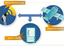
The configuration of the PPU is similar to that of the base station. A PPU typically includes a GNSS/DGPS/RTK receiver (rover station) with two antennas to acquire the vessel’s direction, one WiMAX Mobile Station (MS) to communicate with the base station and software that connects the GNSS/DGPS/RTK receiver with the WiMAX MS, controls the PPU receiving the reference data and transmits the accurate position, direction and ROT streaming to the base station.
Testing times: prototype evaluation at the Port of Cork and commercial uptake
The two-year DockingAssist project, launched in November 2011 and funded under the ‘Research for the benefit of SMEs’ programme, developed a prototype of the positioning system, which underwent exhaustive testing at the Port of Cork, the consortium end-user partner.
Perello explains: “We set and configured the entire system and then tested it in October 2013, first in a small ship provided by the Port of Cork, which was very promising, then in a 100m-long container vessel, where the coverage was even better, and finally in a medium-sized vessel.
“We tested all the scenarios and the system performance, including the network capacity, against the project specifications and the results were very good.”
The DockingAssist system has the potential to improve port traffic management and efficiency, as well as increase throughput in European ports with a minimum of investment, allowing SMEs to increase their business in line with demand and reduce operational expenses. Such advancements could also mitigate the environmental impact of shipping by limiting fuel usage and CO2 emissions.
With these multiple benefits in mind, have any of the consortium partners taken the technology out of the prototype stage and into the marketplace in the form of a viable solution?
“Marimatech wants to introduce the WiMax and Wi-Fi technologies into their business lines, and Runcom are also very interested in introducing WiMax networks into ports, which would be a completely new business for them.
“In addition, Net Technologies is looking to be involved in the implementation of the new technology and Prodevelop is integrating some of the geographic information system (GIS) features developed in the management software during the project.
“Around 10%-15% of ports already use WiMax for reasons such as providing internet connections, so there is a real opportunity for them to take advantage of new vessel positioning systems.”
Follow Julian Turner on Google+
