

In the realm of orbital maritime navigation, the four Global Navigation Satellite Systems (GNSS), including the most prevalent, Global Positioning System (GPS), have long been relied upon for accurate positioning and navigation.
However, in certain situations where GNSS signals may be compromised or limited, alternative technologies become crucial. One such technology that has gained attention is the W-band radar.
Access deeper industry intelligence
Experience unmatched clarity with a single platform that combines unique data, AI, and human expertise.
GNSS have become an indispensable tool for maritime navigation, providing accurate positioning, timing, and navigation services worldwide. However, they are not without their shortcomings, which can impact the effectiveness and reliability of maritime operations which is why radar as a supplement to GNSS is vital to the maritime industry.
Despite their great strengths, GNSS have their shortfalls. In maritime environments, signal obstruction can occur due to tall ships, bridges, wind farms, and oil and gas installations. These obstacles can lead to signal loss or reduced accuracy, potentially compromising the safety and efficiency of navigation.

Interference is another issue. Multipath interference occurs when GNSS signals reflect off surfaces such as water or vessels before reaching the receiver. This can result in distorted or delayed signals, leading to inaccuracies in positional calculations.
In maritime settings, where the reflective surface of expansive water is the dominant feature, multipath effects are more pronounced and can introduce significant errors.
Maritime operations often involve challenging environments such as polar regions. In such scenarios, GNSS signals may be weakened or completely unavailable due to signal degradation caused by ionospheric scintillation, multipath effects, or signal blockage. This limitation can hamper navigational reliability in critical situations.
Furthermore, GNSS signals are also susceptible to intentional interference, including spoofing and jamming. Spoofing involves transmitting false GNSS signals to deceive receivers, leading to incorrect position and timing information. Jamming involves the deliberate transmission of high-power radio signals to overpower and disrupt GNSS signals. Both activities can pose significant risks to maritime navigation, as vessels may be led astray or lose access to accurate positioning.
To mitigate these shortcomings, maritime navigation systems often rely on a combination of GNSS with other complementary technologies such as radar. These systems provide redundancy and enhance the overall reliability of maritime navigation, ensuring safer and more efficient operations at sea.
W-band radar is becoming the go-to solution
Marine radar has long been a ubiquitous technology in the shipping industry since its development during World War II. It was mandated in 1942 that all US and British commercial vessels be equipped with radar for safety, navigation, and enemy detection.
Today, modern radar systems are capable of identifying ships, buoys, birds, and other obstacles within a specified radius.
W-band radar provides the most impressive imagery and accuracy, which is becoming increasingly crucial.
The range of traditional radar units is determined by the width of the transmitted pulse and the number of pulses sent per second. Current systems can achieve a maximum range (Rmax) of 24 to 72 nautical miles (44-133km) and a minimum range (Rmin) of 20m.
Most marine radar systems operate on S-band and X-band frequencies. S-band operates at 3GHz and has a range of 40 nautical miles (74km), while X-band operates at a higher frequency of around 10GHz with a wavelength of 3cm, offering better target resolution and high-resolution imaging.
However, W-band radar, a relative newcomer in maritime navigation and operating at 76-77GHz, provides the most impressive imagery and accuracy, which is becoming increasingly crucial in the ever more cluttered environs of offshore, nearshore, and inland waterways. It has a range of 500m and is resistant to adverse weather conditions.
W-band radar can be used in a wide range of near-distance applications, such as berthing, tracking small objects like swimmers and kayaks, and inspecting bridge structures and wind farms within inland waterways.
Autonomous vessels can benefit
When selecting a W-band radar system, it is essential to consider Frequency Modulated Continuous Wave (FMCW) radar, which measures the distance of moving objects.
FMCW radar achieves this by continuously varying the frequency of the transmitted signal over a fixed time period. It provides high-range resolution and accuracy, offers rich data crucial for autonomous and semi-autonomous vessels, and can detect concealed targets and tangential motion effectively.
There are also key strategic benefits of W-band radar for maritime automation and autonomous vessels, revolving around situational awareness.
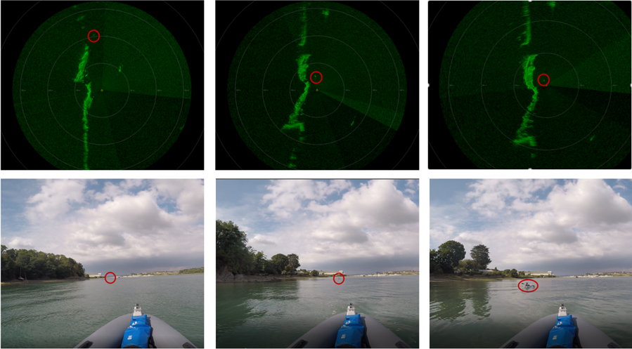
Firstly, Localisation. The radar provides precise millimetre-accurate positioning in changing conditions, allowing decision-makers to confidently navigate through obstacles regardless of visibility or reliance on other positioning technologies.
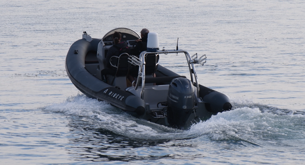
W-band radar can also assist in obstacle detection and tracking. it can identify and locate even small obstacles within a 500m radius, providing their positions relative to the vessel.
Further, it can help with the dynamic positioning of an autonomous vessel. The radar system, along with computer control systems, enables automatic maintenance of a vessel’s position and heading using its own propellers and thrusters.
W-band radar also has the capability to help with autonomous berthing. Radar localisation allows for autonomous berthing by extracting landmarks onshore and in the nearby vicinity.
There are numerous potential benefits of integrating W-band radar in offshore, near shore, ports and terminals, and inland waterway applications.
Utility in Maritime Navigation
Obstacle detection and collision avoidance are crucial aspects of maritime safety. W-band radar can effectively detect and track small objects, such as icebergs, buoys, and other vessels, providing essential data for collision avoidance.
Its high-resolution imagery allows for the early identification of potential hazards, enhancing maritime safety.
In congested port environments where GNSS signals can be unreliable or blocked by tall structures, W-band radar can serve as a reliable navigation aid. It offers real-time position updates and accurate mapping of vessel movements, enabling safe and efficient navigation within confined spaces.
W-band radar’s ability to penetrate fog, rain, and snow makes it a valuable tool for vessels navigating in challenging weather conditions.
Adverse weather conditions often pose significant challenges to maritime operations, including reduced visibility and unreliable satellite signals. W-band radar’s ability to penetrate fog, rain, and snow makes it a valuable tool for vessels navigating in challenging weather conditions. It provides reliable situational awareness and enhances vessel safety.
W-band radar can also play a vital role in search and rescue operations. Its high-resolution imaging capabilities enable effective scanning of the surrounding area, aiding in the detection of stranded vessels or individuals in distress.
Supplementing GNSS
While W-band radar offers unique advantages in certain maritime scenarios, it is important to note that it is not intended to replace GNSS systems entirely.
Instead, it can serve as a valuable supplement to GNSS, providing redundant and independent positioning information. By integrating data from both GNSS and W-band radar, mariners can benefit from enhanced reliability, accuracy, and redundancy in their navigational systems.
In the maritime context, where accurate positioning and navigation are paramount, the utility and application of W-band radar as an alternative or supplement to GNSS systems cannot be overlooked.
Its high-resolution imaging capabilities, ability to penetrate adverse weather conditions, and precise target detection make it an invaluable tool for enhancing maritime safety.
By harnessing the strengths of both technologies, maritime operations can be conducted with greater confidence, resilience, and effectiveness.
What does the future of radar hold?
The current sensor implementation ranges from the increasingly cluttered environment of offshore to the expanding network of strategically significant inland waterways.
What is clear is that technology has a crucial role in complementing and in many cases replacing human processes in vessel management and navigation.
Technology has a crucial role in complementing and in many cases replacing human processes.
Current forecasts indicate that remotely controlled craft will be ubiquitous well within this decade, to be followed closely by unmanned ocean-going vessels, all of which are set to transform maritime and many other industries that depend upon it, from renewable energy to the world’s supply chain.
As sensory systems, from millimetre wave radar to satellite-enabled propulsion controls become ever more commonplace in maritime automation, the fusion of multiple sensors will become the default, of which near-distance radar will be the core.
W-band radar in the maritime context, therefore, is increasingly becoming a necessary supplement to GNSS.