
Dr Wolfgang Koch is head of sensor data and information fusion at the Fraunhofer Institute for Communication, Information Processing and Ergonomics FKIE in Germany, where he works on data fusion for array-sensors, localisation and navigation, wide-area surveillance and threat recognition.
Go deeper with GlobalData

Koch and his team took part in PASSAGES (Protection and Advanced Surveillance System for the Arctic: Green, Efficient, Secure), a joint German-Canadian research project involving Airbus Defence and Space Technology based in Ulm, Germany, as well as exactEarth and Dalhousie University in Canada.
Julian Turner: How did the PASSAGES project come about and what are its key objectives?
Wolfgang Koch: German Chancellor Andrea Merkel met with then Canadian Prime Minister Stephen Harper in 2012 and from that evolved the joint German-Canadian concept study, PASSAGES, looking at how surveillance technologies might be used to encourage shipping in the Northwest Passage. This is especially important for a country like Germany, which is heavily dependent on exports.
Our goal is to combine heterogeneous sources of sensor and non-sensor information in order to provide situation pictures that then form the basis of situational awareness for vessels navigating the area.
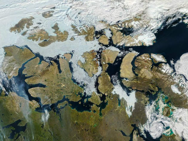
JT: Why is the Northwest Passage considered too dangerous and risky for vessels to navigate?
How well do you really know your competitors?
Access the most comprehensive Company Profiles on the market, powered by GlobalData. Save hours of research. Gain competitive edge.

Thank you!
Your download email will arrive shortly
Not ready to buy yet? Download a free sample
We are confident about the unique quality of our Company Profiles. However, we want you to make the most beneficial decision for your business, so we offer a free sample that you can download by submitting the below form
By GlobalDataWK: The main issue concerns topography. The north of Canada is a highly complex archipelago with many small islands and narrow sea lanes, so navigation is a concern. There are also remnants of ice fields that are changing over time, so it is important that ship captains have up-to-date information in their traffic management systems on the current state of the ice and the route decision-making.
The fact there are a limited amount of routes in the Northwest Passage makes navigation difficult but sensor surveillance and situational awareness easier in that we are able to focus on certain choke points through which ships have to pass, meaning we don’t have to analyse the entire area.
JT: What technologies are being used to map the Northwest Passage?
WK: At present, analysis is limited by the sparseness of the technological resources. Passive radar, which makes use of existing radiation in the form of direct signals from navigation or communication transmitters combined with signals from ships or aircraft, meant we could measure differences in terms of arrival time, frequency and angles, allowing us to localise ships and track them over time.
PASSAGES also employed satellite-based synthetic aperture radar (SAR) and automatic identification system (AIS) sensors, but this was only available in certain time windows, so scientists had to design algorithms to bridge these gaps combined with geographical information to predict target positions.
Our third source of information came from underwater sonar installations in certain choke points in the north of Canada − a legacy of the Cold War − and this surveillance made surface ship tracking possible, in addition to unmanned underwater vehicles (UUVs), which also provided us with data.
PASSAGES also considered information to be gathered by both manned and unmanned patrol flights, and through careful resource management was able to reasonably plan sensor flights.
Finally, there are elaborate models that use geographical and oceanographic information such as currents to predict how sea ice is evolving. By fusing this with the other sensor data, we developed an architecture that generates a situational picture of the Northwest Passage that can be used to inform vessel traffic management systems and future sensor equipment in North Canada.
The navigation radars and sensor coverage provided by the ships themselves is useful but the range is limited and we were unsure whether or not it was reliable – it is not the backbone of this system.
JT: How serious is the impact of global warming and melting sea ice in the region?
WK: Because of global warming the Northwest Passage is becoming increasingly ice-free. This winter the polar ice cap is melting once again, as it did in 2015 when the temperature at the North Pole was close to 0°C, warmer even than Germany at that time.
There are also serious problems to do with the native Innuit population. For large parts of the year the archipelago was open land, but global warming started melting the sea ice, icebreakers opened up sea lanes and now caribou cannot move from one island to another, greatly reducing hunting.
There also are advantages, of course. Remote locations that are home to native populations can now be accessed more easily by harbours and there is an opportunity for Innuit children to attend school. Their traditional life is changing and that’s a complex issue; there is much sociological research to do.
JT: Will increased maritime traffic result in more Arctic pollution and resource exploitation?
WK: Environmental and political issues are also important. The Arctic is very rich in natural resources that could be exploited; in fact, President Obama recently moved to block oil drilling in the Arctic Ocean.
There are also issues of international sea law and the Arctic habitat. The ecosystem is very delicate and if a Deepwater Horizon-type disaster were to happen there it would be much more dramatic. Surveillance and careful situational images of the Northwest Passage are therefore very important.
Another major issue in Canada is illegal fishing. Again, multiple sensor coverage makes it possible for the authorities to find out who is fishing where they are supposed to by detecting foreign trawlers.
Many things we have learned from the Northwest Passage can be used to develop the North East Passage of Russia, but there are military considerations. The political background is that the North East passage is currently not a viable option for commercial shipping following the events in Ukraine.
The ownership of the Northern border of Canada is disputed by the Canadian and US Governments because the shipping lanes are the basis to explore for big-money commodities like oil and gas. The strategic dimension makes it important that we secure the Arctic to prevent conflict over resources.
JT: How far are you from developing a permanent navigation system for the Northwest Passage?
WK: The PASSAGES project demonstrated the potential of sensor solutions that combine passive radar, and satellite AIS and SAR to provide ground pictures based on both simulation and data.
The Fraunhofer Institute is now in discussion with our industrial partner in Germany, Airbus, and our partners in Canada to establish a pilot project to demonstrate the capability of providing surveillance and situational images in the harsh environment of the Northwest Passage based on the current technology, the first step toward realising the vision of a monitoring and information system.